
Map-o-Matic Overview
With Links to Video Tutorials

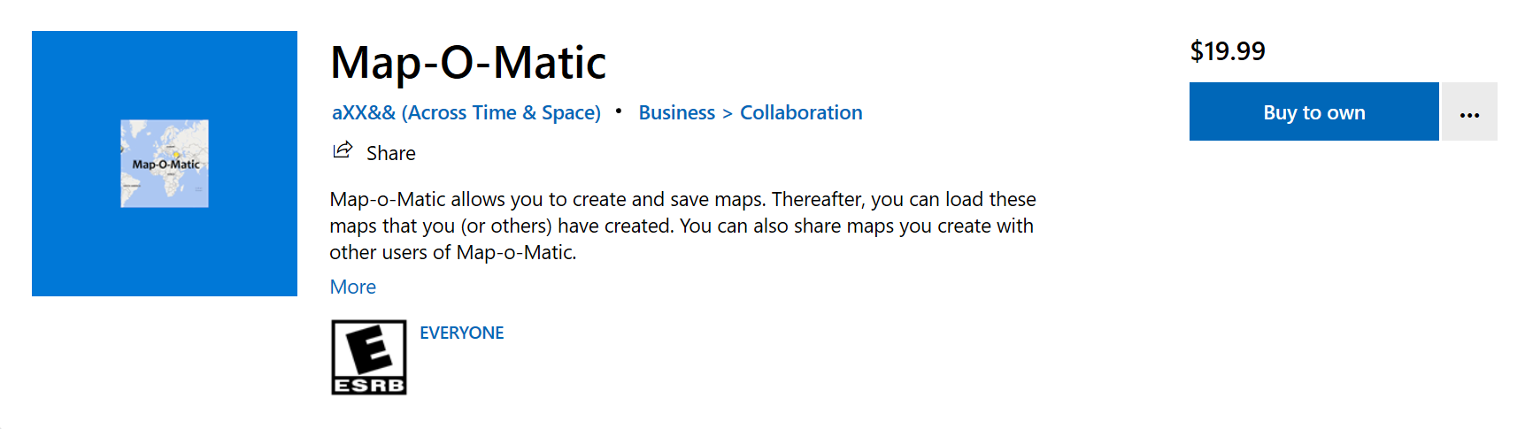
OVERVIEW of the Windows App “Map-O-Matic”
For those who prefer to watch videos explaining Map-O-Matic and how to use it, skip down a few pages and you will find a table containing links to several videos available on YouTube.Map-o-Matic, which allows you to create, save, and share custom maps, is now available in the Microsoft Store:
With Map-o-Matic, you can load these maps that you (or others) have created. You can also share maps you create with other users of Map-o-Matic.
The maps are not viewable by just anyone, though. Maps created using Map-o-Matic are stored locally (that is to say, they are saved on your computer, not “in the Cloud”). This keeps your data safer. You can opt to share maps you create with others, though.
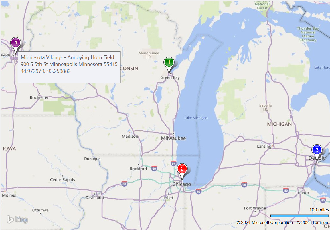
The locations which are shown on your maps are displayed as numbered “pushpins,” and incorporate whatever description or explanatory information that you have provided about the location. This information is seen when hovering over the pushpins/locations. For example, here is one simple map with four locations:
Besides displaying the pushpins at the locations you have designated, and displaying information about each spot when hovering over them, you can also select from 15 colors for each pushpin so that you can “color-code” locations based on whatever criteria is important to you.
For example, a map of Civil War era battles may use Blue for Union victories, Gray for Confederate victories, Red for Native American victories, and Black for inconclusive results.
There’s no limit to how many maps you may create, or purposes for which you may need to create maps that can be displayed on demand at any time. Examples of people and professions who may benefit from Map-o-Matic includes, but is not limited to:
Detectives
Researchers
Teachers
Real Estate Agents
Delivery people
Hobbyists
Historians
Writers
Content Producers
Tinkers, Tailors, Soldiers, Spies, &c (although I’m not necessarily promoting soldiering or spying – or even tinkering and tailoring, for that member).
For those who prefer to learn by recorded videos, everything you need to know about using Map-O-Matic can be learned from the following videos I have created on YouTube. This is probably the preferred way of learning what you need to know as you need to know it. So, without further ado or adon’t, here are a series of video tutorials:
General Overview of Map-o-Matic
Brief Overview of all the menu items
How to Create a Map Manually
How to Create a Map from a Text file
How to Load an Existing map
How to Convert a map to a text file
How to zoom in or out
How to add a location to an existing map
How to remove a location from an existing map
How to update a location on an existing map
How to delete a map
How to change the map style
How to copy a map to the clipboard
THE TWO WAYS OF CREATING A MAP IN MAP-O-MATIC
There are two ways to create your own custom maps in Map-o-Matic: the “safest” way (less prone to user error, that is to say) is by entering the data directly into the app. The other way is by loading a properly formatted text file containing the information that describes the locations for your map; Details and examples of these types of text files will follow.
Here is a quick overview showing examples of the two ways you can create maps in Map-O-Matic:
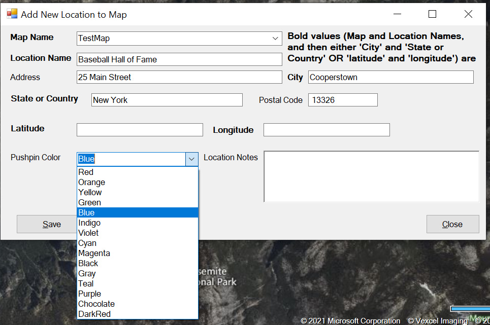
You can enter the information about a location on a map in the form that displays when you select File > Add Location on an Existing Map Manually. In that case, you will enter information such as this:
The alternate method, as mentioned above, is to create a text file with location data in it, and then select File > Create New Map and Locations from File.
A file you load may look like the following (format-wise, that is, not the specific data it contains):
Gray~Battle of Pensacola (January 8–November 23, 1861);30.433333;-87.2Gray~Battle of Fort Sumter (April 12–13, 1861);32.752222;-79.874722Black~Battle of Gloucester Point (May 7, 1861);37.27;-76.498611Black~Battle of Sewell's Point (May 18–19, 1861);36.954722;-76.326667Black~Battle of Aquia Creek (May 29, 1861 – June 1, 1861);38.3893;-77.3157Blue~Battle of Arlington Mills (June 1, 1861);38.860833;-77.116389Black~Battle of Fairfax Court House (June 1, 1861);38.8525;-77.304167Blue~Battle of Philippi (June 3, 1861);39.15316;-80.04278In the data above, the coordinates (but not the address) are being provided. The color followed by a tilde (~) at the beginning of each line indicates the color to make the pushpin. From the tilde to the first semicolon is the text you will see when hovering over the pushpin. The latitude and then longitude follow.
Below is what the file would look like if you are providing the address rather than the coordinates:
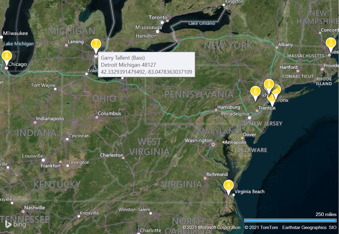
Bruce Springsteen (Vocals, Guitar);;Long Branch;New Jersey;07740Steven Van Zandt (Guitar);;Winthrop;Massachusetts;02152Max Weinberg (Drums);;Newark;New Jersey;07101Clarence Clemons (Saxophone);;Chesapeake, Norfolk County;Virginia;23320Roy Bittan (Keyboards);;Rockaway Beach, Queens;New York;11691Danny Federici (Keyboards);;Flemington;New Jersey;08822Garry Tallent (Bass);;Detroit;Michigan;48127In this case, no colors have been specified, and so the default pushpin color (Gold) will be used for all locations. The text up to the first semicolon is the information that will be seen when hovering over the pushpin. Then there is an area for street address, but in this particular file they are left blank in each case, so there are two semicolons in a row in all instances shown above. Then there is the City, the State, and the Postal (Zip) Code. Only City and State or Country are required – the street address is not, nor is the Postal code.
When a street address is used, it looks like this:
Gary Richrath (Guitar);157 Riverside Avenue;Champaign;Illinois;61820Here’s what you see when hovering over the birthplace of the bass player for the E Street Band:
You can also create “hybrid” text files (some of them providing the coordinates, others the address information). Here is an excerpt of such a hybrid file:
Red~Campo (mile 1.4);32.606389;-116.468056Orange~Lake Morena (mile 20);2550 Lake Morena Drive;Campo;California;91906Yellow~Mount Laguna (mile 41.5);32.872222;-116.4175Green~Julian (mile 77.3);33.070833;-116.585556Blue~Stagecoach Trail RV Park (mile 77.3);7878 Great Southern Overland Stage Route;Julian;California;92036Indigo~Montezuma Valley Market (mile 101.2);Montezuma Valley Market;Ranchita;California;92066Violet~Warner Springs (mile 109.5);33.282222;-116.633611Black~Holcomb Village (mile 111.3);33.35122525088887;-116.73760707493621Gray~Anza (mile 151.9);33.555;-116.673611DarkRed~Paradise Valley Café (mile 151.9);61721 State Highway 74;Mountain Center;California;92561Chocolate~Hemet Lake Market (mile 168.6);56570 Highway 74;Mountain Center;California;92561Teal~Idyllwild (mile 179.4);;Idyllwild;California;92549Purple~Cabazon (mile 209.5);;Cabazon;California;92230MORE SPECIFIC INFORMATION ABOUT CREATING TEXT FILES WITH VARIOUS EXAMPLES
The first thing you need to do to create a map form a text file, of course, is to create the text file. You will need to provide the pertinent information, with each element of data delimited by a semicolon (;). Each location should be on one line (not literally, necessarily – it’s okay if your record wraps over to another line/row, just don’t manually hit the Enter key to move to force a move to the next line (until you’re ready to add a new record).
The text files must be in this format:
[Location name];[Address];[City];[State];[Zip]For locations outside of the U.S., you can view it this way, although it’s the same type of information:
[Location name];[Address];[City];[Country];[Postal Code]Note: The text in the first place (“Location Name”) can actually be whatever you want; it’s “free text” – just don’t put any semicolons in it until the end. This will display in the “tooltip” when you hover over the Location’s pushpin on the map (along with the address, coordinates, and any comments you add).
The “Address” spot can be left blank. All other values (City, State/Country, and Zip/Postal Code) are required. If you leave “Address” blank, you will have two succeeding semicolons. The address is normally needed only for addresses that are very close to each other, such as within the same town or city. If all of your Locations are in different towns/cities, adding a specific address is not necessarily of much value.
As an example, here are a few lines from a file showing all types of situations discussed above:
San Francisco, California;;San Francisco;California;94101Jackass Hill, California ("Mark Twain Cabin");Jackass Hill Road;Tuttletown;California;95370Hawaii;1 Crater Rim Drive;Hawaii Volcanoes National Park;Hawaii;96718Buffalo, New York (First home after marriage);472 Delaware Street;Buffalo;New York;14202Elmira, New York (Quarry Farm, where Twain wrote many of his books);131 Crane Road;Elmira;New York;14901Hartford, Connecticut (Happiest Family Years);385 Farmington Ave;Hartford;Connecticut;06105Riverdale-On-Hudson, New York;;Riverdale-On-Hudson;New York;10471Tuxedo Park, New York;;Tuxedo Park;New York;10987Redding, Connecticut (End of Life, "Stormfield");391 Redding Road;Redding;Connecticut;06896Paris, France;;Paris;France;75000Florence, Italy;;Florence;Italy;50100Chelsea, London, England;23 Tedworth Square;Chelsea London;England;SW3 4DYKaltenleutgeben, Austria;;Kaltenleutgeben;Austria;2380Some of the locations are in the U.S., some are not. Some have addresses, some don’t. Some span over two lines but do NOT contain a “hard break” (which is added by pressing the Enter key). Some of the “Location Name” values are simply the City and State or City and Country. Others have explanatory information such as “Birthplace” or “Boyhood home.” Specifically:
Example of Address left blank (two consecutive semicolons before the name of the city):
San Francisco, California;;San Francisco;California;94101Example of Address provided (no hard line break, although it spans two lines):
Buffalo, New York (First home after marriage);472 Delaware Street;Buffalo;New York;14202Example of non-U.S. location:
Chelsea, London, England;23 Tedworth Square;Chelsea London;England;SW3 4DYIf you have missing semicolons (there are less than 4) or too many semicolons (there are more than 4), it will throw everything off and won’t work correctly, so make sure you have exactly four semicolons for each location – one following each segment of the location except for the last element (Zip or Postal Code).
Note, too, that whatever you named the file will be the name of the map (excluding its extension). For example, if you name your file MrMagoosTravels.scsv or MrMagoosTravels.txt, the map will be named MrMagoosTravels.
FILES INCLUDING THE COORDINATES (LATITUDE AND LONGITUDE) BUT NOT THE LOCATION INFORMATION (CITY AND STATE OR COUNTRY, ETC.)
If you prefer, you can add the coordinates (latitude and longitude) to a file. This allows you to be very precise, and you don’t need to add any other information. You can specify a color for the pushpin, but don’t have to. You can even lead explanatory notes seen when hovering blank, if you want to (you probably will want to add some description of the location, though.
In some cases, you need to use coordinates rather than an address, depending on what it is you are mapping. For example, if you are keeping track of earthquake locations, they (fortunately) don’t always occur at a specific address. The same goes for air or maritime disasters and such.
A file of this type is of this format (this data is a few battles fought in West Virginia during the American Civil War):
Black~Battle of Hancock (January 5–6, 1862);39.6957,-78.177Gray~Battle of Princeton Court House (May 15–17, 1862);37.3657;-81.1017Gray~Battle of Harpers Ferry (September 12–15, 1862);39.3228;-77.7302Blue~Battle of Charleston (September 13, 1862);38.347222;-81.633333In this case we are specifying the color of the pushpin, and there is a reason for the colors. Blue indicates a Union victory, Gray a Confederate victory, and Black an Inconclusive or disputed result.
Let’s break this type of data down. In this entry (row, or record):
Gray~Battle of Harpers Ferry (September 12–15, 1862);39.3228;-77.7302The following bits of information exist:
Gray = the color to make the pushpin
Battle of Harpers Ferry (September 12–15, 1862) = the value to display when the pushpin is hovered
39.3228 = the latitude
-77.7302 = the longitude
(battles, too, do not always occur at a specific address, so this is another example of data that needs to be provided with the coordinates).
If you have questions, comments, feature requests, etc., about Map-O-Matic, feel free to email me at axx3AndSpace@gmail.com