


HOW TO USE MAP-O-MATIC (#7 in a Series)
Map of Worst U.S. Maritime Disasters, from 1857 to 2019

This brief tutorial on Map-O-Matic demonstrates the file needed to display pushpins for the 18 worst maritime disasters in U.S. history, from 1857 to 2019 (taken, for the most part, from the 2021 World Almanac).
I wrote, “for the most part” because I added one that (being a huge Mark Twain fan) is close to my heart: the 1858 explosion of the Pennsylvania, a steamboat that Twain had just departed but on which his younger brother Henry was still working. For “the rest of the story” on that, see this (note in the “hover text” following the pushpin color designator in the list below that the first shipwreck also has a Mark Twain connection).
Without further ado, here is the file I used to create the map of the 18 worst U.S. maritime disasters:
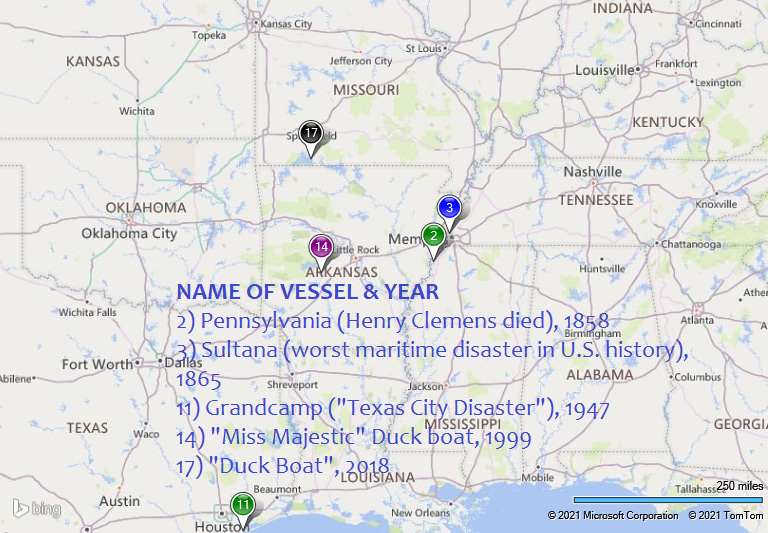
Red~Central America ("Ship of Gold") Captain Herndon (wrote "Exploration of the Valley of the Amazon" which Mark Twain read and caused him to want to go to South American to pursue a business in Coca) - 9/12/1857;31.583333;-77.033333Green~Pennsylvania (Mark Twain's brother Henry Clemens was on board and subsequently died of his injuries) June 3, 1858;34.65944;-90.480675Blue~Sultana (worst maritime disaster in U.S. history, exploded while carrying six times as many passengers as ship was designed for) 4/27/65;35.190556;-90.114444Orange~Mary Celeste (her captain deliberately wrecked her off the coast of Haiti as part of an attempted insurance fraud) 11/7/1872 (exact location of shipwreck is a guesstimate);19.989571;-73.625557Purple~Pacific - 11/4/1875 (coordinates approximate - "about 25 miles (40 km) southwest of Cape Flattery");48.206815;-125.110594Teal~General Slocum - 6/15/1904 (coordinates approximate - East River, near North Brother Island);40.799018;-73.905395Gray~Larchmont - 2/11/1907 (coordinates approximate - "off of Watch Hill and Block Island";41.237888;-71.733013Black~Eastland - 7/24/1915;41.887222;-87.631694Chocolate~Princess Sophia - 10/25/1918;58.6022;-135.0236Red~Morro Castle - 9/8/1934;40.2281;-73.9942Green~Grandcamp ("Texas City Disaster") 4/16/1947;29.3775;-94.891389Blue~Andrea Dorea and Stockholm - 7/26/1956;40.491667;-69.85Orange~Edmund Fitzgerald (subject of 1976 song by Gordon Lightfoot) 11/10/1975;46.9985;-85.110167Purple~"Miss Majestic" Duck boat (coordinates approximate) 5/1/1999;34.441072;-93.079909Teal~Andrew J. Barberi - 10/15/2003;40.644112;-74.072578Gray~El Faro - 10/1/2015;23.2;-73.7Black~"Duck Boat" - 7/19/2018;36.587778;-93.318333Chocolate~Conception – 9/2/2019;34.0475;-119.735This is the map it produces (with captions added):

As you can see, some areas had too many disasters in too small an area to see them all. So, I zeroed in or zoomed in on two areas: the central U.S. (on and near the Mississippi River), and the East coast.
Here is the central area:
...and here is the East:

For more details and ideas on how to use Map-O-Matic, see the previous Map-O-Matic tutorials in the series from the links below.
Map-O-Matic Tutorial #1: https://ramblingnotesofageezer.substack.com/p/how-to-use-map-o-matic-1-in-a-series
Map-O-Matic Tutorial #2: https://ramblingnotesofageezer.substack.com/p/how-to-use-map-o-matic-2-in-a-series
Map-O-Matic Tutorial #3: https://ramblingnotesofageezer.substack.com/p/how-to-use-map-o-matic-3-in-a-series
Map-O-Matic Tutorial #4: https://ramblingnotesofageezer.substack.com/p/how-to-use-map-o-matic-4-in-a-series
Map-O-Matic Tutorial #5: https://ramblingnotesofageezer.substack.com/p/how-to-use-map-o-matic-5-in-a-series
Map-O-Matic Tutorial #6: https://ramblingnotesofageezer.substack.com/p/how-to-use-map-o-matic-6-in-a-series